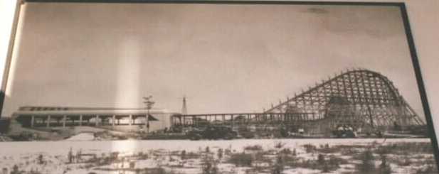
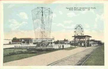
1939 Pontchartrain Beach moves from Spanish Fort to Milneburg
Pontchartrain Beach is moved to Milneburg. This photo shows the Zephyr under construction. The Zephyr roller coaster was built by Edward Vettel. (Source: http://members.aol.com/coasting2/zephyr.html). The 60-acre amusement park also included the Port Pontchartran/Milneburg lighthouse that had been located offshore before land reclamation. "The Beach" closed in 1983 and is now the location of the UNO Technology Park.
1931 The Spillway Opens
The Corps of Engineers builds the Bonnet Carre Spillway, a safety valve which can be opened when the Mississippi River floods, protecting New Orleans from high water. The water can be diverted from the river to Lake Pontchartrain. It is opened for the first time in 1937.
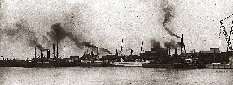
Oil and gas exploration first takes place in the Lake. Due to environmental problems related to this industry, such as wetland loss from canal dredging, and pollution from oil spills, since 1992 there are no new oil and gas drilling leases allowed in Lake Pontchartrain.
Photo credit: http://www.mvn.usace.army.mil/pao/bcarre/design.htm
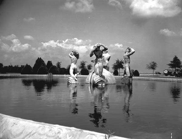
1930s - Enrique Alfarez sculpture at Shushan Airport
Title of Sculpture: Fountain of the Winds
Set in the fountain at the New Orleans Lakefront Airport--formerly named 'Shushan Airport. Sculpted during the 1930's under the WPA program
The Artist: Enrique Alfarez
Source: New Orleans Public Library
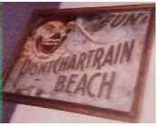
1930s Pontchartrain Beach TIn Sign
Pontchartran Beach moved from Spanish Fort to Milneburg (near Elysian Fields Avenue) in 1929
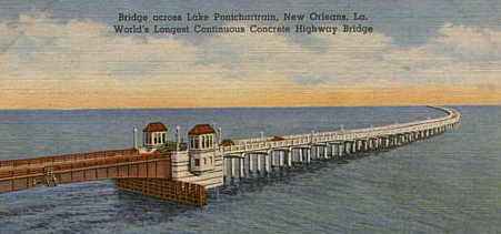
World's Longest Bridge
1930s postcard entitled, "Bridge across Lake Pontchartrain, New Orleans, La. World's Longest Continous Concrete Highway Bridge".
This bridge, which is known to locals as the "5 Mile Bridge" spans from New Orleans East to Slidell. It lost its "World's longest..." title to the Causeway Bridge in the 1950's.
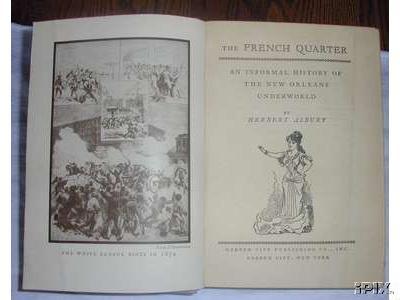
Duel IN the Lake?
In the book A history of Creole New Orleans from a Unique Viewpoint
(Published in 1938 by Garden City Publishing Co.) a nearly 7 foot tall
blacksmith who, when challenged to a duel by a famous duelest replied, "Very
well. We will meet in six feet of water in Lake Pontchartrain armed with
sledge-hammers". The famous duelest, who was only five feet eight inches tall
declined and withdrew the challenge.
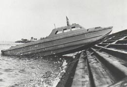
Higgins Industries designs the Eureka--prototype of the LCVP a.k.a. Higgins Boat
During the 1930's, Higgens Industries developed the 'Eureka'--a boat designed to fit the needs of local fishermen and water workers. It is shown (below) running up on the Lake Ponchartrain seawall to demonstrate it's unique cabilities. This boat will be slightly redesigned to become the WWII LCVP or 'Higgens Boat) The Higgens Boats were crucial to the success of the D-Day Invasion.
Higgens simply enlarged the 'Eureka' and added a bow ramp at the request of the Marine Corps and the LCVP design was complete. Without Higgins' uniquely designed craft there could not have been a mass landing of troops and material on European shores or on the beaches of the Pacific islands, at least not without a tremendously higher rate of Allied casualties.
Richard (Rabbit) Brown was a reguar at Mama Lou's
1880-1937 - Richard Rabbit Brown--early Blues
He was a regular at Mama Lou's on Lake Pontchartrain. If "business was slow and [Brown] need a ride home, he would turn in a false fire alarm." The firemen answered the call and found out it was only their friend, who sang to them as they went back to the station. Brown "sang to his guitar in the streets of New Orleans, and he rowed you out into Lake Pontchartrain for a fee, and sang to you as he rowed." From an essay by Kevin S. Fontenot. Source: http://www.bluesworld.com/RabbitBrown.html
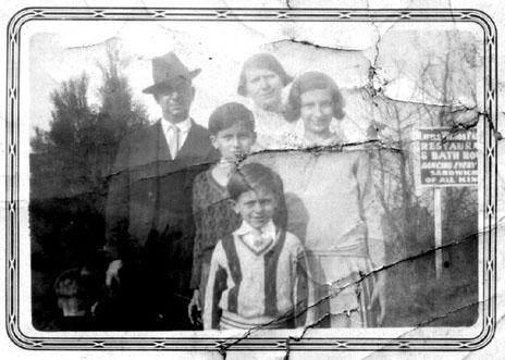
Alcide (Yellow) Nunez (Jazz great) & his family in Little Woods
1884-1934 - Alcide (Yellow) Nunez Alcide P. Nunez, wife Hilda, and children Alcidie, Robert, and Eugene at Little Woods, New Orleans. Around 1930.
1884-1934 - Alcide (Yellow) Nunez #2
"Alcide Nunez played with a band called "The Moonlight Serenaders" over local radio station WCBE. I think this photo is from about 1927. Nunez is at the far left. Second from left is Carl W. Satter. Third from left is banjo player Frank Chappetta. Fourth from left is drummer John Malloy.* I have a few guesses, but no positive identifications of the other musicians. Any help is welcome; email froggy@neosoft.com In 1928 WCBE moved their studios to the DeSoto Hotel and changed their call letters to WDSU. Some locals may know that WDSU is still in business. In addition to the WCBE job, The Moonlight Serenaders are said to have broadcast on WWL radio, played regularly along the lakefront north of New Orleans at places like Milenburg and Little Woods. They accompanied the Boswell Sisters early in their carrer.* Source: http://www.geocities.com/BourbonStreet/5135/WCBE.html
Source: http://www.geocities.com/BourbonStreet/5135/WCBE.html
1932 - Smoky Mary ceases running to Milneburg
The popularity of Milneburg began to wane as the West End and Pontchartrain became big attractions. The development of a seawall along the lake, prohibition and the last run of Smokin Mary in 1932 signaled the end of the village.
1934 fire in Milneburg destroyed the town
When the Smoky Mary (Pontchartrain Railroad) stopped running to Milneburg in 1932, its popularity declined. Milneburg closed after the development of the seawall that displaced several buildings in the resort. The site later became the Pontchartrain Beach Amusement Park and the surrounding reclaimed land became the Lake Terrace/Lake Oaks neighborhood. The 1934 fire destroyed most of what remained and "Milenburg" as it was, was no longer.
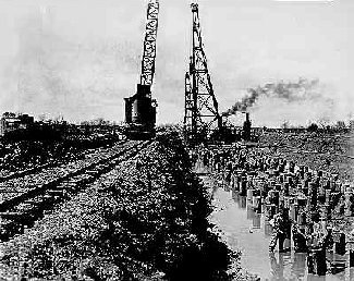
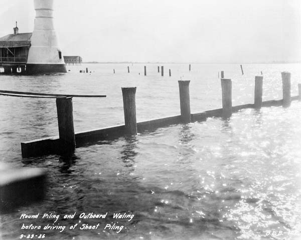
Photo (9/29/1926) shows round piling and outboard waling before driving of sheet piling on the lakefront [at the Milneburgh lighthouse] to reclaim land from the lake. When completed, the Milneburg lighthouse will be on land.
Photo Credit: http://nutrias.org/photos/wpa/images/24/240801.jpg
1939 Lincoln Beach is founded
Lincoln Beach was founded in 1939, when the Orleans Levee Board purchased 2.3 acres near Little Woods to be set aside as a swimming area for black residents (this was during a time when segregation was the norm) ...Over the next few years, Lincoln Beach became a vacation destination. New rides sprang up on the midway; and the park hosted concerts by such popular acts as the Ink Spots and local favorites Fats Domino and Earl King. In April 1957, Lincoln Beach was selected as the site of the annual Negro State Fair, a gathering that highlighted education and culture.
Source: New Orleans Magazine
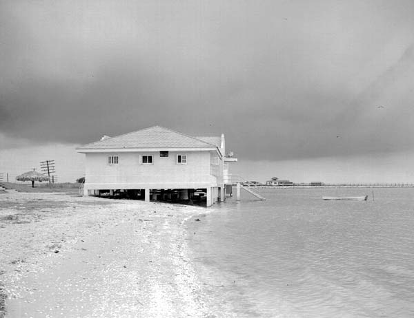
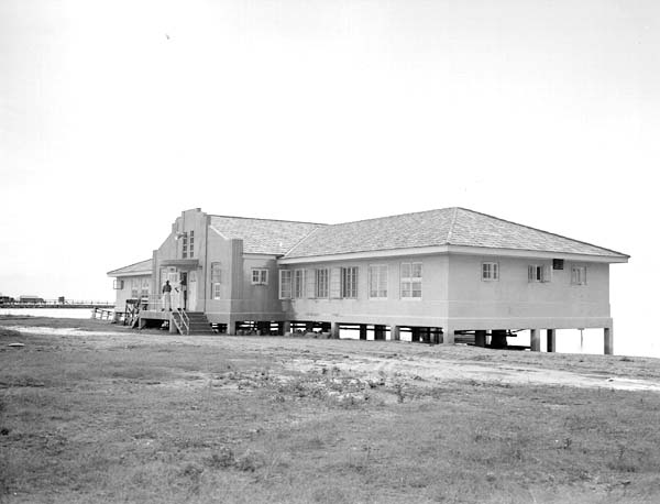
Photo shows a Lincoln Beach bath house (May 29, 1941)presumably while the amusement park was under construction. Photo credit: http://nutrias.org/monthly/july2001/6jul01.htm
1936 Bayou St. John is declared non-navigable
For many, Bayou St. John offered the possibility of living in houseboats. However, with the 'ragtag' nature of the houseboats, the decline of the corridor as a critical part of the trade route, and the Bayou's increased use as a holding basin for city drainage, the area experienced a general deterioration in its condition. By 1936 it was declared a non-navigable stream. Today the Bayou is a pleasing green space connecting residential areas surrounding City Park both to one another and to the park.
Source: http://www.new-orleans.la.us/cnoweb/cpc/1999_dist_four.htm
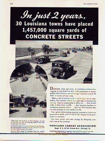
1930's - Lake Shore Drive opens
A 1940 ad for Portland Cement, reads "...in just two years, 30 Louisiana towns have placed over a million square miles of concrete streets." Includes photos of Lake Shore Drive,Lawrence Street in Lake Charles, and First Street in Morgan City.
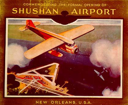
1934 - Shushan Airport opens (now New Orleans Lakefront Airport)
Under the direction of Governor Huey P. Long stalwart Abe Shushan, the Orleans Levee Board built a state-of-the-art airport at a cost of $3 million on a filled-in area of Lake Pontchartrain in New Orleans. It was the FIRST COMBINED LAND AND SEAPLANE AIR TERMINAL IN THE WORLD. The new facility, called Shushan Airport, hosted the Pan-American Air Races as part of its opening ceremonies in February 1934. Just before the races started, officials barred women from competing, a controversial move. On the first day of contests, a crash claimed the life of a stunt pilot. A parachute jumper and a pilot died three days later after the jumper's chute caught on the tail of the plane. These races demonstrated once again the risks of air stunts. Jimmie Wedell entered the races and flew the '45' to a new 100-kilometer world speed record of 266 miles per hour. The '45' was expected to be his most spectacular speed ship, the basis for his successful bid to the United States Army for a pursuit-plane design.
Source: State Museum online exhibit--Louisiana Aviation since 1910
http://lsm.crt.state.la.us/museum/aviation/wedell3.htm
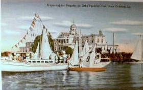
1930s or 40s- Regatta
Postcard titled "Preparing for Regatta on Lake Pontchartrain, New Orleans, La. " Linen Era (1930-1945) Signed by A. Hirschwitz, New Orleans, LA. on back. Published by Genuine Curteich, Chicago. Description--"Sailing regattas are enjoyed on Lake Ponchartrain. Southern Yacht Club, second oldest in America, is seen in the background. Card part of the ?New Orleans - America?s Most Interesting City? series."
1939-WPA Builds the Bulkhead for Artificial Sand Beach at Lincoln Beach
This photograph from May 25, 1939 shows a bulkhead built by the WPA as part of the construction of the sand beach at Lincoln Beach. Notice the camps along the shore to the right.
1939-WPA Builds the first Bathhouse at Linclon Beach
Before the desegregation of public facilities in the 1960s, Lincoln Beach was the African-American recreation area on Lake Pontchartrain. The lakefront property off Hayne Blvd. where the beach was located was originally deeded to the City by Samuel Zemurray in 1938, and the next year the land was purchased by the Levee Board. WPA workers built a bathhouse and a sand beach beween 1939 and 1941 and the beach opened to swimmers. Later, a small amusement park was added. But inadequate bus service, the lack of amenities, and the beach's distance from New Orleans proper prevented the area from becoming a popular destination in its early years. By 1952, the Times-Picayune described Lincoln Beach as "a barren sand beach and a lone, unimpressive building" -- the bath house pictured here, shortly after its construction by the WPA in 1941). But the next year brought a renaissance for Lincoln Beach when the Levee Board began a half-million dollar renovation of the property, including fresh water swimming pools, a new bath house, picnic shelters, and an expanded and rebuilt midway. Source: http://nutrias.org/~nopl/monthly/july2001/4jul01.htm
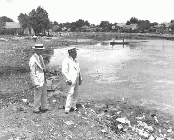
1938 Mayor Maestri surveys Bayou St. John
New Orleans Public Library
City Archives
Mayor Robert S. Maestri Photographs
Photo 9
WPA Project Tour, July 11, 1938
Hampton Reynolds (Chairman, City Planning Commission) and Mayor Maestri.
[WPA Photo]
Source: http://nutrias.org/~nopl/photos/rsm/rsm9.htm
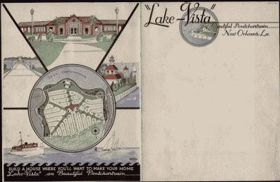
1930s ? Lake Vista Prospectus
Lake Vista on Beautiful Pontchartrain, New Orleans, Louisiana Developement Prospectus advertising brochure ca. 1930's, 11" spine,3 pp.
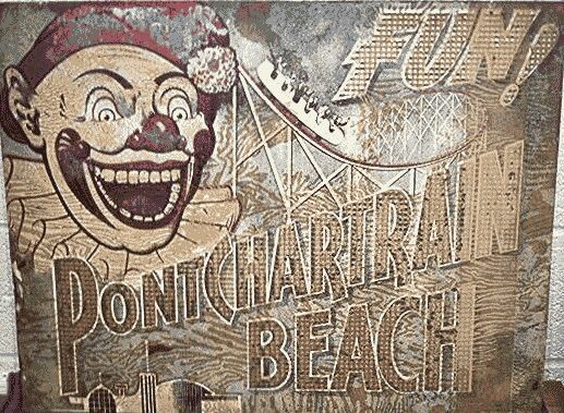
1930s ? Pontchartrain Beach Sign
27 by 21 inch tin sign.
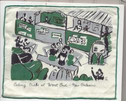
1930s - Eating Crabs at West End
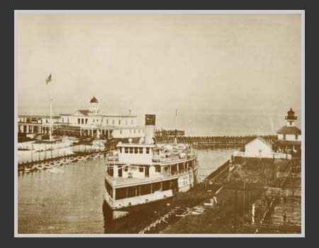
1930s New Basin Canal at West End
Docked at the New Basin Canal at West End is one of the popular excursion boats that carried New Orleanians across Lake Pontchartrain in the early years of this century. There were the "Susquehana," the "Camellia," the "Southland," and the "Madisonville." To the left is the Southern Yacht Club and on the right is the Coast Guard Station. As the breakwater (in the photograph it appears to be blocking the entrance to the canal) was constructed in the early 1930's and the last excursion boat ran in 1936, this photograph must have been made sometime in between. Plying between New Orleans and the North Shore, the boats provided an exciting outing. Aboard were first rate jazz bands, beer, saucisson, and German pretzels. The open decks provided a breezy relief from the hot summer. Once ashore on the far side, passengers picnicked or treated themselves to a sumptuous meal at Bechac's on the beach at Mandeville. Photograph provided by J. Gilbert Scheib, Southern Yacht Club.
Collection of Frank Gordon & Son
New Orleans, Louisiana USA
Source: http://www.bergeronstudio.com/fg01/p56.html
1935 - The Smoky Mary Ceases to Exist
the oldest railroad west of the Alleghenies-the Pontchartrain Railroad, five miles long, which extended "straight as a string" on Elysian Fields Avenue, in New Orleans, from the Mississippi River to Lake Pontchartrain, at Milneburg. This line was abandoned in 1935, after some 104 years of uninterrupted service. For seventy-four years, the L&N linked New Orleans with the Central-South and the Mississippi Valley. ~ Source: http://nutrias.org/~nopl/exhibits/choochoo/page2.htm
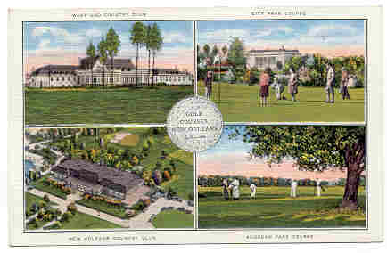
1935 - West End Golf Course
Hard to read postcard depicts the "West End Golf Course" in the upper left.
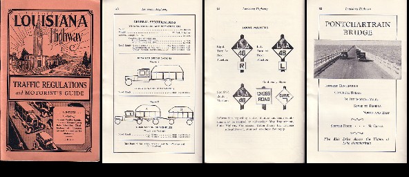
1933 Louisiana Highway Traffic Regulations Guide
A 64 page booklet, "Louisiana Highway Traffic Regulations and Motorist's Guide," containing 1933 traffic regulations and license laws, rate schedules (cost of licenses by date and manufacture of car, and horse power - there are 7 pages of such rates!), classification of licenses, and general information for motorists, with illustrations. Published by the State Highway Commission, edited by Col. E.P. Roy, Superintendent of the State Highway Patrol of the Louisiana Highway Commission. With portaits of Roy, Governor Allen, and Senator Huey Long. Includes two pages about the Pontchartrain (5 mile)Bridge from New Orleans to Slidell.